

Most appraisal disputes don't start with the value opinion. They start with something on page 14 — a comps map with a buffer nobody can explain, a flood exhibit pulled from a source that isn't named, a subject photo cropped in a way that raises questions the appraiser can't answer six weeks later. The narrative is defensible. The math checks out. But the exhibits fall apart under scrutiny because nobody wrote down where they came from or how they were built.
Why exhibits are questioned
Why exhibits are the first thing questioned — and the hardest to defend after the fact
That gap has a name worth using: appraisal exhibit governance. It's the set of rules that make every visual in a report traceable back to its source, reproducible by someone who wasn't in the room, and consistent across appraisers. And it's one of the most under-built systems in small and mid-size firms, precisely because exhibits feel like a finishing step rather than a workflow that actually needs controls.
This isn't a checklist article about "make sure your maps are clear." It's about how exhibit creation connects to your data sources, your review process, and your archive — and what breaks when a firm grows from three appraisers to fifteen without ever formalizing any of it.
Exhibits built from memory
Exhibits are built from memory, not from a system
Manage every appraisal with confidence and clarity.
Rateoly helps you coordinate inspections, generate reports, and communicate seamlessly with clients.
- Comprehensive appraisal tracking
- Automated client notifications
- Integrated scheduling & report management
No credit card required
Walk through how a typical map or exhibit actually gets made in a smaller shop. An appraiser opens a mapping tool, drops the subject pin, eyeballs the comps, draws a boundary or radius that "looks right," exports the image, and pastes it in. Maybe they screenshot a FEMA panel. Maybe they grab a plat from the county site. The exhibit looks professional. It communicates the point.
-
Which map layer or basemap version was used
-
What date the flood or zoning data was pulled
-
Why the buffer is 1 mile and not 0.75
-
Whether the comp locations came from MLS coordinates or were manually placed
-
Who created the exhibit and when
None of that lives anywhere. It lived in the appraiser's head for about ten minutes and then evaporated. When a reviewer, a lender, or a state board asks "how did you arrive at this?" the honest answer is often "I don't remember exactly."
This tends to work fine right up until it doesn't. A solo appraiser carries the whole method in their head and rarely gets challenged. The instant you add reviewers, trainees, or multiple offices, the absence of a documented method turns every exhibit into a small liability. Two appraisers draw comp maps following completely different rules, and neither can say why.
Provenance stamping basics
Provenance stamping: the missing metadata layer
The fix for "I don't remember" is provenance stamping — attaching a small, standardized block of source-and-method data to every exhibit at the moment it's created, not reconstructed later.
-
Source — where did the underlying data come from? (MLS, county GIS, FEMA NFHL, a specific parcel dataset, a photo taken on-site)
-
Date pulled — when was that data current as of?
-
Method — what rule produced this exhibit? (1-mile radius, market-area polygon, comparable subdivision boundary)
-
Author — who built it?
-
Version — which iteration is this, and did anything change from the last one?
You don't need this printed loudly on the face of every exhibit. A small caption line handles the visible portion — "Comparable map, 1.0 mi radius; comp coordinates from MLS; base imagery [source], pulled 04/18." The fuller record lives in the file's supporting documentation.
The insight most firms miss: provenance stamping is cheapest when it's automatic and upstream. If appraisers are typing source notes by hand after the fact, half will skip it and the other half will get it wrong. The data about where a comp came from already exists at the moment the comp is selected — the trick is capturing it then, not asking someone to reconstruct it during final assembly. This connects directly to how you handle comp mapping in the first place; if you've built repeatable geospatial methods and buffer rules for map exhibits, the provenance becomes a natural byproduct rather than an extra chore.
Source disclosure reference
Source disclosure rules: knowing what actually has to be named
Not every data source carries the same disclosure weight, and treating them all identically is how firms end up either over-cluttering exhibits or under-documenting the ones that actually matter. A useful exercise is building a simple source-disclosure reference — something that tells appraisers, for each exhibit type, what must be named and how current it needs to be.
Here's a working version:
| Exhibit type | Required source disclosure | Freshness rule | Common failure |
|---|---|---|---|
| Comparable location map | Comp coordinate origin (MLS vs. manual), base imagery source | Comp data current to report date | Manually nudged pins with no note |
| Flood exhibit | FEMA panel/NFHL, panel number, effective date | Panel effective date shown | Screenshot with no panel ID |
| Zoning/land-use map | Municipal source, ordinance date | Verified within assignment | "Per city website" with no date |
| Plat / parcel exhibit | County recorder or GIS, parcel ID | Current record | Cropped image, no parcel reference |
| Subject/comp photos | On-site vs. MLS vs. street-level, capture date | Photo date matches inspection | MLS photo passed off as field photo |
| Aerial / topographic | Imagery provider, capture year | Reasonable recency for context | Years-old imagery with no year noted |
The exhibits that get firms in trouble aren't the fancy ones. It's the routine ones — the flood screenshot, the borrowed photo — where a careless source shortcut creates an integrity question that has nothing to do with the actual value. A photo lifted from an old listing and presented as a current field shot is a small thing that can undermine an entire report's credibility if a reviewer catches it.
For anything touching market boundaries and adjustments, source discipline matters even more, since the exhibit is often the visual justification for a number. If your location-adjustment protocol references market indicators, the exhibit illustrating the market area needs to name the same sources the adjustment relies on — otherwise the narrative and the picture are telling two different stories.
Scaling failures
What breaks at scale
Exhibit chaos is invisible at low volume. The cracks tend to show at predictable points as a firm grows.
Solo / 2–3 appraisers. Everyone shares an informal style. Exhibits look roughly similar because there's essentially one house method held in shared memory. Risk is low but so is documentation — the whole system depends on the individuals staying consistent.
4–8 appraisers, first reviewer. This is where the seams show. The reviewer starts seeing maps built with different buffers, photos with inconsistent naming, flood exhibits from different tools. Review time balloons because the reviewer has to reverse-engineer each exhibit's method before they can even evaluate it. A firm at this stage can lose a real chunk of QC capacity just decoding how exhibits were made.
Multiple offices / 10+ appraisers. Now you have genuinely divergent local practices. The Phoenix office does comp maps one way, the Tucson office another. A lender working with both notices the inconsistency. Recreating an exhibit for a two-year-old file becomes nearly impossible because the source data has moved on and nobody recorded what it looked like at the time.
The through-line: the cost of missing provenance doesn't grow linearly with firm size — it compounds. Each undocumented exhibit is a small debt, and at scale you're carrying thousands of them, any one of which can surface in an audit or a complaint.
Exhibit workflow
A reproducible exhibit workflow
The goal isn't more paperwork. It's making the right capture happen automatically inside the work appraisers are already doing.
-
Define exhibit templates. For each exhibit type, lock the format: dimensions, required caption fields, legend standards, and the provenance block. An appraiser filling a template can't accidentally omit the source line — it's a required field, not a suggestion.
-
Bind the source at selection. When a comp is pulled or a data layer is added, the origin gets attached automatically. The coordinate source, the pull date, the panel number — captured at the point of action, not retyped later.
-
Apply the method rule explicitly. The buffer, polygon, or boundary comes from a documented firm standard, and the exhibit records which rule was applied. If an appraiser overrides the default (say, a market-area polygon instead of a radius), the override and the reason get logged.
-
Stamp and version on export. Every exported exhibit carries its provenance and a version tag. Regenerate it later and the version increments with a note on what changed.
-
Review against the template, not from scratch. The reviewer checks that the exhibit followed the standard — which is fast — instead of forensically reconstructing how it was built.
-
Archive the exhibit with its source snapshot. The file stores not just the image but the underlying source references, so the exhibit can be recreated even after the live data has changed.
The step most firms skip is number six. They keep the PNG and throw away the context.
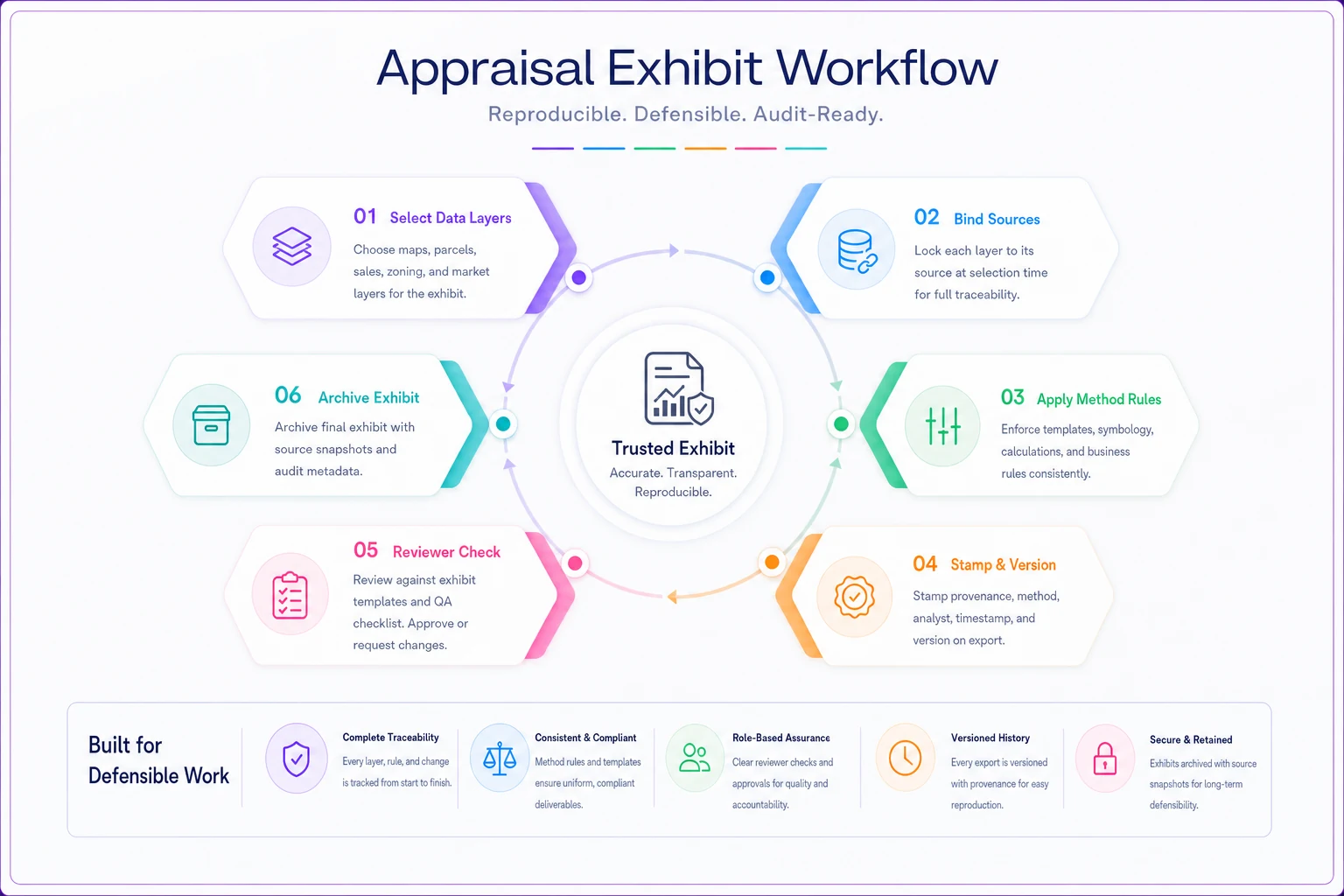
This diagram shows the handoff points where provenance data should be captured and where versioning and archival snapshots are attached.
Keep source snapshots immutable and link them to exhibit version tags so recreations match exactly.
Two years later the map is undefendable — not because it was wrong, but because the world it depicted no longer exists in any recoverable form. That single habit, archiving the source alongside the exhibit, is probably the highest-leverage change a firm can make.
AI-assisted tooling
Where AI-assisted tooling actually helps here
This is exactly the kind of quiet, repetitive capture that AI-assisted operational platforms handle well — not as a headline feature, but as plumbing. When your exhibit workflow runs inside operational software with AI automation, the provenance stamp gets assembled from data already flowing through the system: the comp source, the pull timestamp, the applied buffer rule, the author. Nobody has to remember to add it.
The genuinely useful part isn't generating exhibits automatically — it's catching what's missing. An AI-assisted review step can flag a flood exhibit with no panel date, a photo whose metadata doesn't match the inspection date, or a comp map where a pin was moved off its MLS coordinate without a note. Those are precisely the small inconsistencies human reviewers miss when moving fast through a stack of files. The judgment stays with the appraiser; the software just makes sure it's documented and the sources are named.
Real scenario
A short real scenario
A five-appraiser firm in a mid-size metro was fielding a steady drip of lender requests to "clarify the comparable map methodology" — a few a month, each costing an hour or two of back-and-forth. Nothing dramatic, but it added up. One AMC had started flagging the firm's exhibits as inconsistent between appraisers.
They did two things. First, they standardized exhibit templates with a required provenance caption. Second, they moved comp source and buffer rule capture to happen at selection rather than final assembly. No new headcount, mostly just a change in how the existing workflow was structured.
Over the following quarter, the map-clarification requests dropped to one or two total, and the AMC's inconsistency flags stopped. The harder-to-measure win: when a two-year-old file got pulled for a board inquiry, the reviewing appraiser recreated the exact comp map from the archived source snapshot in about fifteen minutes — something that would previously have taken half a day of guessing, if it was even possible at all.
When to implement
When to build this out — and when not to bother yet
When it makes sense. If you have more than one appraiser producing exhibits, or a review function, or work you might need to defend years later — which is basically all appraisal work — formal exhibit governance pays for itself. The moment a second person has to understand how a first person built something, you need a documented method.
When it's overkill. A true solo shop doing low-complexity residential work with a consistent personal method can probably run lighter. Though even then, the archive-with-source habit is cheap insurance. Provenance stamping matters most when other people have to trust or recreate your work.
Who should not do this halfway. The worst outcome is a firm that adopts templates but keeps provenance capture optional. You end up with exhibits that look governed but aren't — the caption field is there but half-empty, which is arguably worse than no standard at all because it implies a rigor that isn't real. If you're going to require provenance, make it a hard field, not a suggestion.
Summary
Bringing it together
Exhibits are where a defensible appraisal quietly becomes an indefensible one — not because the work was bad, but because the method wasn't recorded. Provenance stamping, standardized templates, clear source-disclosure rules, and archiving exhibits alongside their source snapshots turn every map and photo into something a reviewer can trust and recreate without you in the room.
The firms that handle this well don't treat exhibit governance as a documentation burden bolted onto the end of the process.
They build it into the moment the data is selected, so the record writes itself. That's the difference between a report that survives scrutiny and one that survives only as long as the person who made it can remember how.
Ready to elevate your appraisal operations?
Join 500+ appraisal firms using Rateoly to enhance accuracy, save time, and improve client satisfaction.